Showing posts with label weather picture. Show all posts

Wednesday, 17 July 2024

Has Summer Arrived?

What a difference a day makes. This morning's picture capture from NOAA 15:

NOAA 15 at 17 Jul 2024 08:18:36 GMT

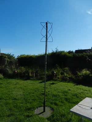
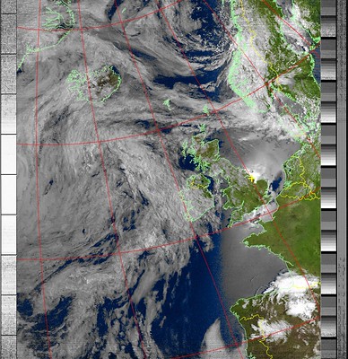
Most of the UK with clear blue skies and 20C already at 9.45 a.m.. Long may it last. BTW. The little yellow cross on the map indicates the position of my aerial.

Tuesday, 16 July 2024

A Drop or Two of Rain

For once the forecast of heavy rain proved to be correct - an inch of rain in a few hours this morning.

Screenshot 2024-07-16 at 12.15.06

I received a weather picture from The NOAA 19 weather satellite a couple of hours after the rain. Plenty of cloud cover!

Screenshot NOAA 19. 2024-07-16 at 11.18.06

The actual signal shows on the right hand side of the screen grab. On the left are the two pictures as they are transmitted, visible light on the left and IR picture on the right. These are then combined in software and false colour added to give a final picture:

NOAA 19 at 16 Jul 2024 10:10:48 GMT

I am receiving clearer signals now the weather satellite aerial in mounted on top of my mast.

Home made QFH aerial for WXsat reception

At one stage during the downpour I noticed the flooding in the garden was getting too close to the robot mower ...


... so it was on with the wellies and out for a quick paddle. Fortunately the water hadn't reached the batteries or circuits. As the ground is nowhere as saturated as it was a couple of months ago the flooding is already subsiding.

Monday, 1 February 2021

Snow or Rain?

On impulse tonight I decided to try to capture a night pass from the NOAA 18 weather satellite. Haven't tried a night pass for years so I had almost forgotten how to set up the software. Anyway this is the result showing the mass of cloud about to sweep across the UK bringing snow or rain according to the weather forecasters:

NOAA 18 at 01 Feb 2021 21:12:18 GMT

Obviously the land outlines and land colouring were added by the software as there is no visible light picture transmitted at night. The horizontal grey speckles are caused by my receiver picking up some local interference. I have the same problem with amateur radio. One day I will find out what is causing it.

Friday, 2 October 2020

Storm Alex (NOAA weather satellite)

The wind crculating round Storm Alex as seen by NOAA 18 this morning:

NOAA 18 at 02 Oct 2020 10:14:45 GMT

Although Alex will move southwards a new low developing over the UK will drag in high winds and rain over the weekend. The Met Office site is now showing amber warnings for some areas.

Tuesday, 11 August 2020

A Mixed Bag

 A few evenings ago I tried several times to photograph the Sunbeams poking out above some dark clouds. They weren't very bright so this is best I managed.

DSCN0497 

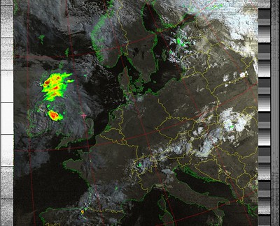
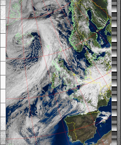
Lovely Sunny day here. A cooling breeze from the coast is helping to keep the temperature down to reasonable levels. This was the NOAA 18 weather satellite picture from just before midday local time. 

NOAA 18 at 11 Aug 2020 10:26:22 GMT 

The red Sunflower is facing away from the Sun so it looked really spectacular with the Sunlight glowing through its petals

 DSCN0505 

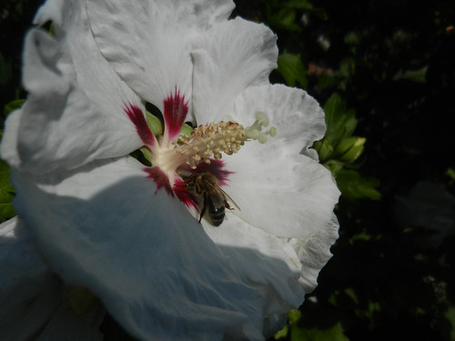
Finally the Hibiscus is in flower and attracting lots of bees 

DSCN0509 

The Sunflower is attracting bumble bees but, unusually, they are too shy to be photographed.

Friday, 7 August 2020

Warming Up

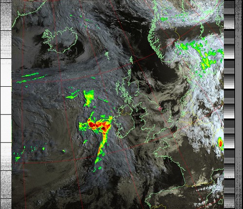
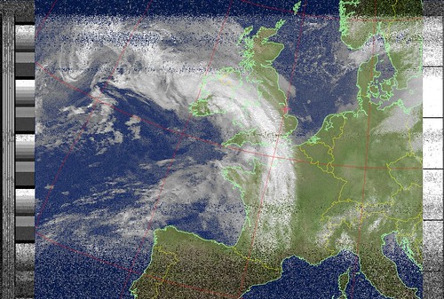
 Picture from NOAA 15 weather satellite at 9 a.m. local time.

  NOAA 15 at 07 Aug 2020 07:50:15 GMT 

Already 24C here and looks to be around 27C in the SE corner of England.

Saturday, 25 July 2020

Temperatures

As you may have gathered I am fascinated by all aspects of our weather systems.
Once the satellite map information has been decoded it is possible to see the recorded temperatures as I move the mouse over the map.

From NOAA 19 at 08.10 this morning (BST)

NOAA 19 at 25 Jul 2020 07:12:23 GMT

While the ground temperature here (where the salmon coloured cross is on the map) is about 19C the air higher up is in the region of 10C. To the south of the ROI the red / black heavy rain area shows cloud temperatures ranging from -30C to -60C. No wonder the temperature at ground level can drop so sharply in a heavy rainstorm. I assume that area is the one which is forecast to bring heavy showers to Lincolnshire later this afternoon.

Friday, 24 July 2020

Tomorrow's Rain?

I see the Met Office is predicting some heavy showers for tomorrow.
BBC Weather predicting possible electrical storms tomorrow afternoon for E Midlands.

Is this what is on the way? (the red area)

NOAA 19 at 24 Jul 2020 07:24:09 GMT

Captured from the 08.22 (BST) pass of NOAA 19

 NOAA 18 at 24 Jul 2020 10:39:58 GMT

NOAA 18 (11.37 BST)

Wednesday, 22 July 2020

Soon be Harvest Time

It's a while since we walked right to the end of the lane.
Good to see the field of grain ripening.

DSCN0457

DSCN0459

Looking at a weather satellite pass first thing it looks as though it could be a bit on the wet side 'up North'.

NOAA 19 at 22 Jul 2020 06:07:03 GMT

Thursday, 16 July 2020

Tuesday, 14 July 2020

Weather Satellites

There are many satellites keeping an eye on the weather systems around the world. There are three NOAA satellites I can receive the picture information from. These are polar orbiting satellites circling the Earth N to S or S to N depending which orbit they are on. Also they move a bit from E to W on each orbit so the whole world can be covered. Each polar orbit takes about 1hr 40min.

From this mornings passes of NOAA 19 near the UK.

First pass to the East of us:

NOAA 19 at 14 Jul 2020 05:58:33 GMT

the next pass to the West of us

NOAA 19 at 14 Jul 2020 07:39:29 GMT

It takes approximately 12 minutes for each picture to be received as they are built up in horizontal lines as the satellite moves round the globe. The yellow cross marks the position of my ground station which is receiving the pictures.

If you are interested in receiving these weather pictures yourself then have a read through 'DIY Satellite Ground Station' HERE for information on how to get started on Windows or MacOS computers.

Sunday, 12 July 2020

Receiving Weather Satellite Pictures

Many years ago I built a kit receiver for capturing the pictures from polar orbiting weather satellites. Unfortunately it is no longer supported and can't receive the signals from the latest satellites. A few days ago I spotted an article written by two young lady amateur radio enthusiasts detailing how to use an SDR (software defined radio) to do the job. It can be found HERE.

This is the SDR

IMG_0256

a receiver in a USB dongle which is controlled and tuned by software on a computer. The above mentioned article gives very clear, detailed instructions how to set things up on a Windows or Mac computer. I downloaded and installed everything needed for my MacBook.

The other thing required of course is an aerial. Several types are discussed in the article.
Fortunately I still had the aerial I built years ago.

DSCN0453

This is the most complicated type to build and gives excellent reception.

There are three programs running on the computer.
One to control the SDR and tune it to the satellite signal.

IMG_0260

One to decode the signal and build up the pictures.

IMG_0255

The third is a hidden program used to channel the sound from the receiver to the map processor.

Received pictures look like this

NOAA 15 at 12 Jul 2020 08:44:52 GMT

in fact two pictures side by side, one normal light and the other IR.

Once they have been received the software processes them together, adds false colour and country outlines to produce different combinations:

NOAA 15 at 12 Jul 2020 08:44:52 GMT

NOAA 15 at 12 Jul 2020 08:44:52 GMT

Those are pictures I received this morning.
This has been a quick outline of what I did. If you fancy having a go do look at the article mention at the start of this post.
Related Posts with Thumbnails