Showing posts with label weather. Show all posts

Wednesday, 17 July 2024

Has Summer Arrived?

What a difference a day makes. This morning's picture capture from NOAA 15:

NOAA 15 at 17 Jul 2024 08:18:36 GMT

Most of the UK with clear blue skies and 20C already at 9.45 a.m.. Long may it last. BTW. The little yellow cross on the map indicates the position of my aerial.

Tuesday, 16 July 2024

A Drop or Two of Rain

For once the forecast of heavy rain proved to be correct - an inch of rain in a few hours this morning.

Screenshot 2024-07-16 at 12.15.06

I received a weather picture from The NOAA 19 weather satellite a couple of hours after the rain. Plenty of cloud cover!

Screenshot NOAA 19. 2024-07-16 at 11.18.06

The actual signal shows on the right hand side of the screen grab. On the left are the two pictures as they are transmitted, visible light on the left and IR picture on the right. These are then combined in software and false colour added to give a final picture:

NOAA 19 at 16 Jul 2024 10:10:48 GMT

I am receiving clearer signals now the weather satellite aerial in mounted on top of my mast.

Home made QFH aerial for WXsat reception

At one stage during the downpour I noticed the flooding in the garden was getting too close to the robot mower ...


... so it was on with the wellies and out for a quick paddle. Fortunately the water hadn't reached the batteries or circuits. As the ground is nowhere as saturated as it was a couple of months ago the flooding is already subsiding.

Tuesday, 13 December 2022

A Negative Day

Woke up to another colder than usual day for mid December here. As the readings (stored on the Wunderground web site) from my new weather station show it never reached the dizzy height of 0C all day - up to the time of writing:

2022-12-13

My old weather station was starting to become unreliable so I invested in a new one which I installed a few days ago when the temperature was better at +3C. The indoor readout is quite spectacular:

DSCN1314

A large display, bright and clear, readable from anywhere in the room as it is hung on the wall. It comes with the outdoor sensors as usual but also has an extra module which I have in the unheated conservatory to show temperature and humidity in there. The only reading which needs adjusting is the air pressure. That is a bit fiddly to set on this display.

I didn't really want to get out of bed this morning but eventually surfaced to the winter wonderland. Looking at some of the greenery you would be forgiven for thinking it had been snowing

DSCN1331

but it is just days of accumulated frost building up on everything. As the ice in the bird baths is now too thick to remove easily yesterday I put out a large plant-pot saucer filled with fresh water. This morning the ice in it was 10mm thick but I managed to remove it and refill with water. The Pied Wagtail was one of the first to take advantage. That was at 9 a.m.. By midday it was frozen solid again and needed refilling.

DSC00011

It has been spending most of each day in the garden. As it will only search for food at ground level I scatter some seed on the grass for it to find. There appears to be a possibility we may have some snow tomorrow, Wednesday.

Monday, 12 December 2022

Misty, Icy Weather

Temperature dropped to -5.3C at one point in the early hours of the day with freezing fog. It has stayed below 0C all day with a cold mist. The area looks as though Nature has added its own Christmas decorations to everything.

DSCN1317

DSCN1318

DSCN1320

I don't think the spider webs will be catching much ..

DSCN1324

It always surprises me that this is the time of year the corkscrew Hazel starts to produce its catkins ready to open when Spring warmth returns.

DSCN1321

DSCN1322

Some shots were a bit hurried as my fingers were freezing but at least there was no snow, yet, so walking about was easy.

Sunday, 16 January 2022

1135 Km/h Pressure Wave

The enormous explosion from the under sea volcano near Tonga caused not only a tsunami across the Pacific but also a pressure wave in the atmosphere which sped right round the Earth. The speed of the pressure wave was estimated to be about 1135 Km/h by Sandy Macdonald in a post on Twitter. Many weather watchers, amateur and professional, noticed the sudden drop in pressure as the effect passed over their locality - mine included:

Screenshot 2022-01-15_22-44-55-941

a steadily dropping air pressure all day with a sudden change at 7.14 p.m. local time. The same person predicted that a second wave would be detected about 2 a.m. local time resulting from the pressure wave travelling in the opposite direction. (Think about the way ripples travel in a pond when a pebble in dropped in the water.) From this morning's pressure readings here it certainly looks as though he was correct:

Screenshot 2022-01-16_09-06-09-987

There definitely appears to be a sudden drop at 1.49 a.m. local time. It looks a deeper drop but the scales are different on the two graphs.

Wednesday, 31 March 2021

A Day For Trimming

As the forecast was for another scorcher of a day it seemed the ideal time for a trimming session or two. The first was my head. Since I first trimmed my hair to 3mm a few years ago I try to keep it that way with a monthly going over. This morning was perfect for that as when I trim it in cold weather the back of my neck always feels freezing when we go walk-about.

Early on there was some cloud cover though it didn't prevent the temperature from gradually rising. When the Sun finally broke through then things really hotted up for the end of March. Maximum recorded here being 24.4C.

Screenshot 2021-03-31_16-22-02-756

As the lawn was dry and in need of a trim the afternoon task was to get that over and done with.

IMG_0444

Time to absorb a bit of that Sunlight and boost the natural vitamin D production.

Friday, 2 October 2020

Storm Alex (NOAA weather satellite)

The wind crculating round Storm Alex as seen by NOAA 18 this morning:

NOAA 18 at 02 Oct 2020 10:14:45 GMT

Although Alex will move southwards a new low developing over the UK will drag in high winds and rain over the weekend. The Met Office site is now showing amber warnings for some areas.

Wednesday, 26 August 2020

Bye Bye Storm Francis

This is what the storm looked like from NOAA 15 the evening before landfall:

NOAA 15 at 24 Aug 2020 18:48:47 GMT

I couldn't get a picture on the day as my weather satellite receiving aerial isn't totally waterproof.

Statistics recorded by my weather station:

Storm Francis

First the rain arrived. When that stopped it was followed by the strong gusty wind. As that started to die down more rain followed. I recorded about 0.9 inches of rain in total. Not too bad. I've known far worse.

Penny spent much of the day asking to go in the garden, poking her head out of the back door, turning straight round and going back to bed to cross her legs.

Did manage our two walks. The morning one during a lull in the rain. After tea it was dry so we went down the lane. As the wind was howling straight along the lane, funnelled between buildings and hedges, it was a case of heads down and lean into the wind on the way back.

Minimal damage here. My plastic garden table was flipped upside down. Better that being blown away. Unfortunately I lost my tallest Sunflower. It had grown over 7 ft high and looked sturdy but a gust snapped the stem at ground level.

Not had to chance to look round the village as yet.


Friday, 7 August 2020

Warming Up

 Picture from NOAA 15 weather satellite at 9 a.m. local time.

  NOAA 15 at 07 Aug 2020 07:50:15 GMT 

Already 24C here and looks to be around 27C in the SE corner of England.

Saturday, 25 July 2020

Temperatures

As you may have gathered I am fascinated by all aspects of our weather systems.
Once the satellite map information has been decoded it is possible to see the recorded temperatures as I move the mouse over the map.

From NOAA 19 at 08.10 this morning (BST)

NOAA 19 at 25 Jul 2020 07:12:23 GMT

While the ground temperature here (where the salmon coloured cross is on the map) is about 19C the air higher up is in the region of 10C. To the south of the ROI the red / black heavy rain area shows cloud temperatures ranging from -30C to -60C. No wonder the temperature at ground level can drop so sharply in a heavy rainstorm. I assume that area is the one which is forecast to bring heavy showers to Lincolnshire later this afternoon.

Friday, 24 July 2020

Tomorrow's Rain?

I see the Met Office is predicting some heavy showers for tomorrow.
BBC Weather predicting possible electrical storms tomorrow afternoon for E Midlands.

Is this what is on the way? (the red area)

NOAA 19 at 24 Jul 2020 07:24:09 GMT

Captured from the 08.22 (BST) pass of NOAA 19

 NOAA 18 at 24 Jul 2020 10:39:58 GMT

NOAA 18 (11.37 BST)

Wednesday, 22 July 2020

Soon be Harvest Time

It's a while since we walked right to the end of the lane.
Good to see the field of grain ripening.

DSCN0457

DSCN0459

Looking at a weather satellite pass first thing it looks as though it could be a bit on the wet side 'up North'.

NOAA 19 at 22 Jul 2020 06:07:03 GMT

Thursday, 16 July 2020

Tuesday, 14 July 2020

Weather Satellites

There are many satellites keeping an eye on the weather systems around the world. There are three NOAA satellites I can receive the picture information from. These are polar orbiting satellites circling the Earth N to S or S to N depending which orbit they are on. Also they move a bit from E to W on each orbit so the whole world can be covered. Each polar orbit takes about 1hr 40min.

From this mornings passes of NOAA 19 near the UK.

First pass to the East of us:

NOAA 19 at 14 Jul 2020 05:58:33 GMT

the next pass to the West of us

NOAA 19 at 14 Jul 2020 07:39:29 GMT

It takes approximately 12 minutes for each picture to be received as they are built up in horizontal lines as the satellite moves round the globe. The yellow cross marks the position of my ground station which is receiving the pictures.

If you are interested in receiving these weather pictures yourself then have a read through 'DIY Satellite Ground Station' HERE for information on how to get started on Windows or MacOS computers.

Sunday, 12 July 2020

Receiving Weather Satellite Pictures

Many years ago I built a kit receiver for capturing the pictures from polar orbiting weather satellites. Unfortunately it is no longer supported and can't receive the signals from the latest satellites. A few days ago I spotted an article written by two young lady amateur radio enthusiasts detailing how to use an SDR (software defined radio) to do the job. It can be found HERE.

This is the SDR

IMG_0256

a receiver in a USB dongle which is controlled and tuned by software on a computer. The above mentioned article gives very clear, detailed instructions how to set things up on a Windows or Mac computer. I downloaded and installed everything needed for my MacBook.

The other thing required of course is an aerial. Several types are discussed in the article.
Fortunately I still had the aerial I built years ago.

DSCN0453

This is the most complicated type to build and gives excellent reception.

There are three programs running on the computer.
One to control the SDR and tune it to the satellite signal.

IMG_0260

One to decode the signal and build up the pictures.

IMG_0255

The third is a hidden program used to channel the sound from the receiver to the map processor.

Received pictures look like this

NOAA 15 at 12 Jul 2020 08:44:52 GMT

in fact two pictures side by side, one normal light and the other IR.

Once they have been received the software processes them together, adds false colour and country outlines to produce different combinations:

NOAA 15 at 12 Jul 2020 08:44:52 GMT

NOAA 15 at 12 Jul 2020 08:44:52 GMT

Those are pictures I received this morning.
This has been a quick outline of what I did. If you fancy having a go do look at the article mention at the start of this post.

Tuesday, 14 January 2020

Weather Station Update

Information from the weather station I have been using since December 2014 has been erratic for the past few months.

DSCN0089

Sometimes when it was teeming down with rain it would record nothing. Every so often the clock would jump to a random time. Also the temperature measurements would suddenly jump up or down several degrees.  A few months ago I took it apart to give it a thorough cleaning and could see the rain gauge had overflowed and soaked most of the electronics and sensors. That is one problem with having everything contained in a single enclosure.

I spent a few weeks perusing various sites and reading reviews with the aim of buying a new weather station. Two of my main considerations were the use of rechargeable batteries on the outside unit, charged in situ, and the ability to send the data to the Wunderground (Weather Underground) weather site.

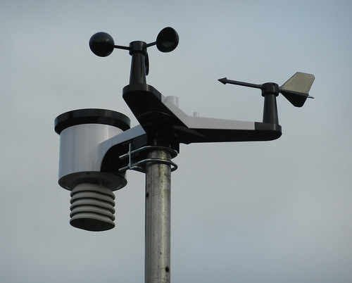
In the end I chose the 'Ventus Colour Weather Station with WiFi Internet Connection' from the Weatherspares site.

weather DSCN0100

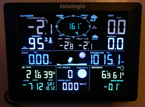
Indoor display (sorry about the reflections)
All digits are white. Only the forecast graphic is in colour.

weather DSCN0102

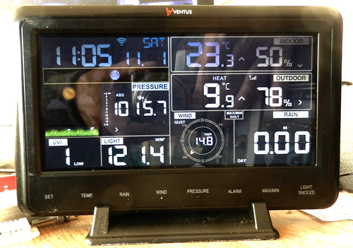
It was dispatched and arrive by courier within a couple of days and took little time to complete the small amount of assembly needed, power it up and make sure the outdoor unit was 'talking' to the indoor display. A free app had to be downloaded to my phone to enable the display to connect to the internet and enable a connection to the Wunderground weather site. Once I had found my way round the menu system on the display I adjusted the barometric pressure reading to a close match to the readings shown on the Met Office weather maps.

The WS View app is available on Apple and Google app stores.
It can also show the present day's readings from the Wunderground weather site.
To view historical data the web site has to be used.

WS View

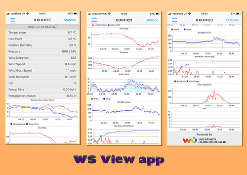
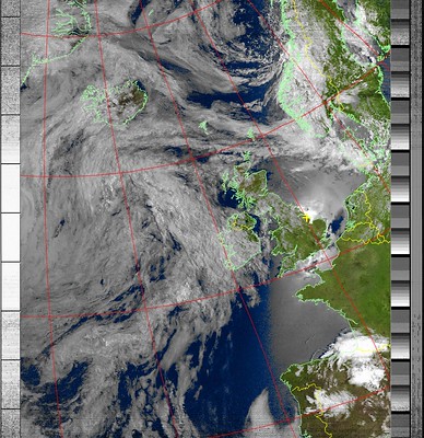
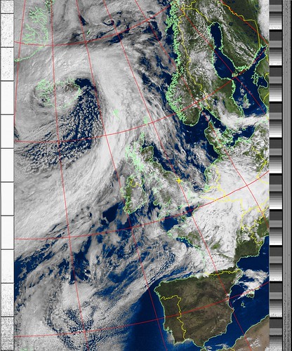
Click on the above collage to see it larger on my Flickr account.

As well as sending data to Wunderground it could also send it to Weathercloud and / or WOW (Met Office Weather Observation Website).

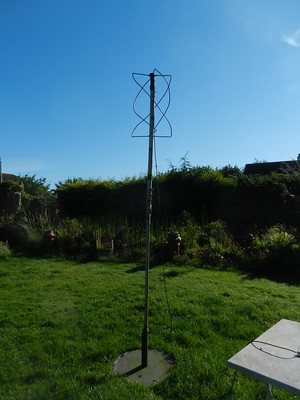
Initially I had inserted Ni-MH rechargeables in the outside unit but by the mornings the display was showing them as about quarter charge even after some decent Sunlight the days before. One of the problems with Ni-Cad and NiMH AA cells is they are only 1.2V whereas alkaline cells are 1.5V. Fortunately I got round to removing the batteries from the old weather station and had forgotten they were:

Cell

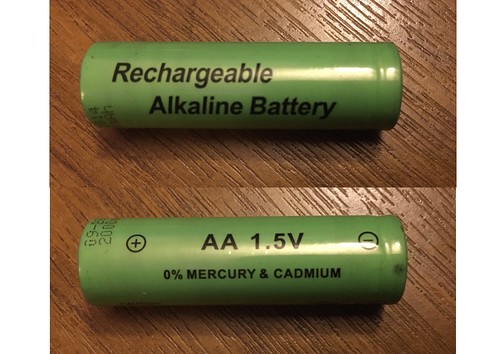
Rechargeable alkaline cells are not so common but they are 1.5V. Even though they had been in continuous use for five years they were still holding their charge so I put them in the new weather station and they seem to be working just fine.

Saturday, 30 November 2019

On This Day

30th November 2019 it is

DSCN0018

DSCN0017

DSCN0020

Could have been worse - 30th November 2017 it was

DSCN7928

Monday, 17 June 2019

Latest Arduino Project

It has been quite a long time since I last had a tinker with an Arduino project. The last one was a weather station with digital readout. That never reached its final stage. All was going well until the day I updated the Arduino IDE (the program used to program an Arduino). The update went badly wrong. It kept reporting errors and wouldn't recognise the instruction I had written previously.

Recently I decided to delete all the old IDE files and install the latest version from scratch. Then a new weather station project on the Instructables site caught my interest. It uses a 3.5 inch full colour TFT display to show the readings in graphical form. The display used is designed to fit on and use with an Arduino Mega. It has a resolution of 480 x 320 pixels.

I found one for sale on eBay direct from China for less than £8 which included postage. After 10 days it arrived. I also had to purchase the tiny unit which actually measures temperature, air pressure and works out the relative humidity. I already had an Arduino Mega.

The sensor module, sensor is the tiny metal box top right
DSCN9700

As always there were other 'libraries' of instructions to install which enable access to the sensor and TFT display. It took a while to find the TFT library files but I discovered a set on the Rinky-Dink Electronics site. They installed and worked perfectly.

Once the program was installed and tested I made some alterations to the original. As well as the graph the most recent readings are now shown numerically just above the X axis. Also I had to alter the range of values on the Y axis to suit the possible range of local readings. At first I thought the pressure readings seemed to be far too high but checking on the Met Office site showed it to be within 1mbar. More accurate than my commercial weather station!

IMG_0678

The display shows up to 36 hours of data (one new reading every 6 minutes) which makes it possible to see weather trends. The above was taken after a 26 hr test run with the unit in the conservatory. When the screen is full the graphs are scrolled from right to left by one pixel with each new reading. Maybe I will change the timing to every 8 minutes so as to display the trend over 48hrs.

Obviously to be of any use the detector needs to be outdoors in a suitable container. Ideally, once I've finished tinkering, I  will have a go at designing and 3D printing a suitable box to hold the Mega and TFT display.

I am so delighted with the possibilities of this colour display I have ordered another one  to experiment with. Screen refresh is slowish so not suitable for displaying video for example.
Related Posts with Thumbnails